Recently, I had a long conversation with Mr Srinivas of ‘Hindu Businessline’ who wanted to write an editorial on this issue. He told me that in the 500 odd words of an editorial all facets concerning the subject could not be covered. That is when I decided to pen down the article. This article is not about our generation, but the next and the next and the next….

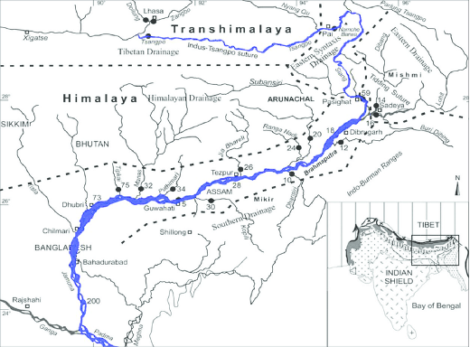
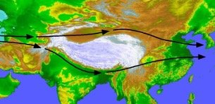
The Brahmaputra River originates in the Mansarovar area of Tibet and is called Tsangpo Yarlung there. It flows Eastwards till the Namcha Barwa Peak and swings south in a loop around it known as the great bend. It enters India through Kepang La near Tuting. It is known as the Siang / Dihang till it hits the plains. South of Pasighat it is known as the Brahmaputra. The map below shows the drainage of the Brahmaputra basin. Very clearly, the river gathers most of its water from tributaries South of the Himalayan crest line. The main tributaries, as any ‘fauji’ who has North East experience would know, are the three Ss (Siom, Subansri and Siang), three Ds (Dibang, Dau and Delai), Lohit, and Teesta.

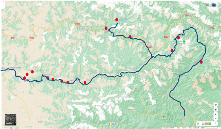
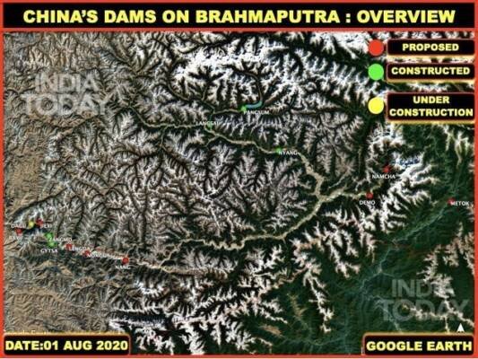
Brahmaputra has figured in news in the recent past. China has announced that it will construct another mega dam in Tibet during the 14th five-year plan. The new dam in Medog County is to be very near the LAC (as close as 30 kms across) in the ‘great bend’. The annotated map in India Today by Col Vinayak Bhatt outlines fourteen dams which China is constructing / constructed on the river. There are more built elsewhere on the Tibetan plateau. In future, China might one day announce some more out of the blue. As lower riparian states, India and Bangladesh have reason to worry. A lot has been written on Chinese dam construction across Brahmaputra, the adverse effect on ecology, seismic activity, water as a weapon and how water flow in India and Bangladesh will be affected. Such routine detail is available in many articles including @
https://timesofindia.indiatimes.com/india/china-plans-dam-on-brahmaputra-how-it-may-impact-india-bangladesh/articleshow/79528597.cms and
https://www.indiatoday.in/news-analysis/story/new-chinese-dam-on-brahmpautra-china-already-has-already-built-11-in-tibet-1745422-2020-11-30

Per se, the volume of water flowing in the Brahmaputra valley will not reduce and there might not be any major effect on its non-availability. However the flow in the Siang/Dihang Valley between Tuting and Pasighat will be reduced/affected due to any Chinese dam in the immediate upstream area in Tibet. This can be offset by a dam in the upper reaches of the river in India to ensure that there is adequate and regulated water flow in Siang. This will also ensure that the ecology is not adversely affected due to undue water variability. This is being spoken of. However in my opinion this is the least of the problems/solutions of this damming activity. There is a need to look beyond that. Let us examine the problems in greater perspective and understand the wider ramifications.
Induced Earthquakes
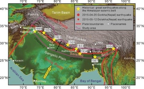
The Himalayas are a very sensitive seismic zone. The number of major Himalayan earthquakes can be seen in the maps above. Chinese mega dams sitting in the lap of such a high seismic zone is a matter of concern. If one dam breaks down there could be a domino effect on others. Also if a natural disaster occurs and in the process a dam also collapses, the result will be catastrophic. However, more than that, the possibility of ‘induced earthquakes’ due to these dams is of gravest concern. All these dams will have water reservoirs of great volume and weight since their heights are great. It is internationally researched and documented that reservoirs can trigger earthquakes. Water bodies increase ground stress which in turn decreases the effective strength of the rock under a reservoir. These factors can trigger earthquakes in areas where considerable tectonic stress is pre-existent. The interplay between the rate of diffusion of water into permeable rock , the permeability of the rock, and the tectonic faults are not predictable. The build-up to a quake will occur deep below the earth’s surface (often kilometres below) It could take years to become lethal enough to trigger a quake. It is also not predictable whether a new reservoir will immediately induce seismicity or experience it. The state of stress and the rock strength deep below where earthquakes occur cannot be measured. All we know is that there are examples of devastating ‘induced earthquakes’ as they occurred at Koyna, India, in 1967, and Xinfengjiang, China, in1962. In fact, the largest and most damaging earthquake triggered by a man-made reservoir is speculated to be the 7.9-magnitude Sichuan earthquake of 12 May 2008. The accompanying danger is that even a mild tremor can accelerate induced seismicity into a major quake.
Local Climate Change
Once a water body is formed, a cycle of local convection and local rainfall sets in. Further due to increased availability of water there is an increase in agricultural activity. This results in greening of the area. This is a cycle which slowly increases the intensity of local convection and rain fall. One fine day a cloudburst happens and landslides take place. Such landslides have been documented and reported in Ladakh. The 2010 landslide is an example where over 200 people have lost their lives. Landslides due to local cloudbursts have also been documented at Kelang Serai, Patseo and Chilam. Global warming and climate change further heightens possibility of local convection events. Such cloudbursts could take place at a distance away from all these dams. For example, if a cloudburst induced land slide occurs in Menchuka, which is far away from the river on our side of the LAC, it could be due to one of the Chinese dams across Tsangpo. One has also to remember that the soil stability of Eastern Himalayas is poor. As the number of dams increase the chances of rise in this phenomenon will also be more.
Effect on Monsoons
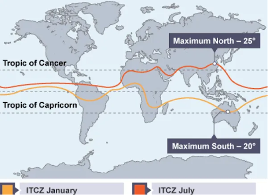
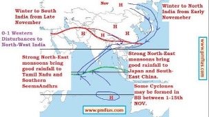
The North East monsoon is a product of two larger phenomenon. The Himalayan jet stream and the Inter Tropical Convergence Zone (ITCZ). The Himalayan Jet stream flows from West to East along the Himalayas after the South West monsoon retreats. (see picture below). The Inter Tropical Convergence Zone, is a belt of low pressure which oscillates between the tropics. (see picture below). This is in concert with the rotation of the Earth around the sun. After September, the low pressure belt shifts into the southern hemisphere. Broadly, the combination of the Jet stream setting in the Himalayas and ITCZ shifting South induces the North East monsoon and brings water to the southern part of the Indian peninsula. This is pictorially depicted in the third graphic. Now in this weather balance , a joker in the pack is being induced in the form of large water bodies due to Chinese dams. October onwards, days are increasingly clear and day temperatures rise in the Himalayan belt. This will produce local convection. As the number of dams increase and water bodies expand , local convection will increase in intensity and scope. What will be the effect of this local convectional turbulence on the North East monsoon system? It is well known that any premature storms and cyclones on our West coast before onset of South West monsoon weakens it to cause droughts in India. Similarly, I suspect that local convections could disturb the NE monsoon system. It will have disastrous results in Indian subcontinent and long term ramifications for India.
Bangladesh Under Threat
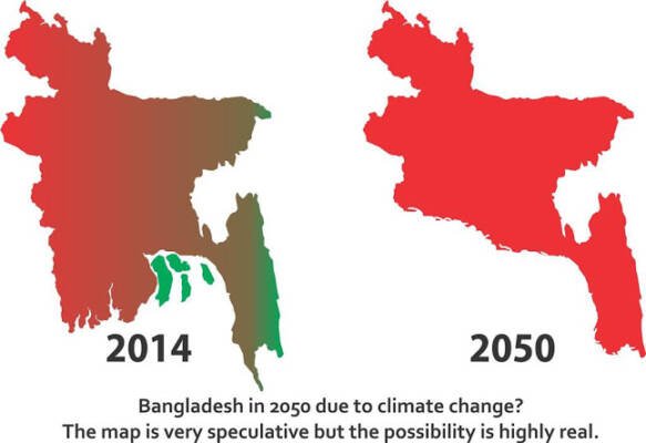
Bangladesh’s low elevation, high density of population and inadequate infrastructure make it extremely vulnerable to climate change. If the sea level rises by 50 cm due to global warming, it will lose 11% of its land. (see map below). It has been estimated that by 2050, this phenomenon will happen in an incremental manner. Up to 18 million Bangladeshi’s may have to move because of rise in sea level. Under such conditions, imagine if China releases stored water to ease pressure on their dams due to heavy rains. The flooding will trigger a humanitarian disaster of massive proportions in Bangladesh. The release need not be to use water as a weapon. It could be forced due to completely natural circumstances. The Chinese have a track record of doing so. The recent rainy season in China saw unprecedented precipitation. Their iconic Three Gorges Dam was under threat of collapse. So what did they do? They released water from a series of dams which make the Three Gorges system and caused floods downstream. They even broke a few embankments to release pressure on the dam. The flooding in the Yangtze basin was so high that Xi Jinping and all his ministers were repeatedly visiting the flooded areas. The complete Wuhan industrial belt was under threat. In the Yangtze valley there was space to release water into plains in a controlled manner. What do you do in the deep gorges of Himalayas which make the Grand Canyon look like a sand model? The Chinese will turn a Nelson’s eye and let the disaster pass downstream. Bangladesh with its increasing embrace of China as part of BRI should know that it is dealing with the devil of its future destruction.
The Chinese Track Record
Ever since the communists have taken over China, their only idea of progress is development by building roads, dams, ports, mega cities, industry and so on. They have hardly given any thought to long term effects of their actions. Contrary to popular belief the Chinese have been extremely short sighted and their leaders have been often blindsided in their approach. They solve today’s problems at breakneck speed without understanding future implications. It is showcased as a ‘Peoples Victory’ in a propaganda glitz. The Chinese people suffer greatly at leisure in history when disaster strikes. Their induced humanitarian disasters are always brushed under the carpet and leaders eulogised despite monumental idiocy. Take the case of their single minded food grain export program during Mao’s Great Leap forward. It caused a famine in which 30-40 million Chinese died due to starvation. Some even resorted to cannibalism! Consider Deng’s ‘One Child Policy’ introduced with great fanfare.
Today China is ageing at an unprecedented rate with a shrinking work force. Their birth rates are low, girls are not prepared to marry to compound their problem. The seed of this long term disaster was sown long back. Their phenomenal development being showcased by Xi Jinping hides phenomenal pollution which will haunt them. Their dam building has already resulted in an earth quake at Sichuan in 2008. Xi Jinping is now re-embarking on this dam building spree in Tibet to get water down to the parched plains of China. He is transferring disaster to India and Bangladesh. Incidentally tampering with the monsoon system will impact the Chinese also. However the Chinese do not know it and the elite communists do not care. The future be damned. All Xi Jinping wants is to get into the same mausoleum as Mao for immortal glory.

Way Forward
Overall, the Chinese dam building spree will result in disasters – long and short term. I have outlined some of them with a ‘man without a dog’ research output. So what do we do? It is time for India to put together an interdisciplinary team to study the issue and come out with a proper document highlighting the long and short term fall out. In a wider scenario, China’s tampering with transnational river systems has had adverse effect on nations and people. The Mekong basin nations are affected, so is Myanmar through the Irrawaddy and Salween Rivers and Pakistan due to Chinese dams on Indus. India needs to start a wider movement officially at UN and through other fora/agencies as part of fight against Global Climate Change. Locally, India and Bangladesh should take up the case with China in a stronger manner through economic and commercial leverages. We cannot afford to let our guards down. This problem has to be tackled on a people’s war footing. If ever people have to pushback for the next generations and those to come ahead, it is this.
-The writer was India’s DG Artillery. He is highly decorated and qualified with vast operational experience. He contributed significantly to the modernisation and indigenisation of Artillery. He is now a Professor in the Aerospace Department of IIT Madras and is involved in applied research for defence technology. The views expressed are personal and do not necessarily reflect the views of Raksha Anirveda